iFANN
    iFANN durchsuchen...
    Anmelden
    Startseite
    Nachrichten
    Videos
    Fotos
    GIFs
    Entdecken
    Umfragen
    Auszeichnungen
    iFAMOUS
    Wiki
    Anime
    Räume
    Benachrichtigungen
    Nachrichten
    Lesezeichen
    Profil
    WikiAuszeichnungeniFAMOUSRanglistenBranchenCreator-BelohnungenBenutzerbelohnungenNutzungsbedingungenDatenschutzCommunity-RichtlinienEntfernung / DMCAHilfeEntwickler

    © 2026 iFANN

    Startseite
    Suche
    Nachrichten
    Alarme
    Profil
    Foto
    Scarlett S
    Scarlett S@scarlett_s1mo
    💭News💭Info/Editorials
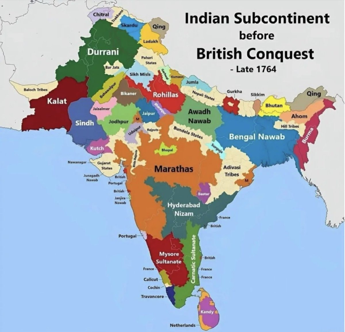
    India map late 1764 before British conquest

    @scarlett_sA map of india from late 1764, before the british conquest. it shows territories like durrani, kalat, sindh, kutch, marathas, hyderabad nizam, mysore sultanate, bengal nawab, and awadh nawab. european colonial areas like british, portuguese, french, and netherlands are also marked

    Originalbeitrag ansehen

    India map late 1764 before British conquest

    Foto von @scarlett_s· Jul 26, 2026· News

    Über dieses Foto

    The image is a historical map of the Indian subcontinent. It shows various regions and kingdoms before the British conquest, specifically labeled as "Late 1764." The map uses different colors to delineate territories such as Durrani, Kalat, Sindh, Kutch, Marathas, Hyderabad Nizam, Mysore Sultanate, Bengal Nawab, and Awadh Nawab. The style is informational and educational, with clear labels for each region and some smaller territories. A notable detail is the presence of European colonial territories like British, Portuguese, French, and Netherlands marked on the map. The title "Indian Subcontinent before British Conquest - Late 1764" is prominently displayed at the top right.

    Alle Fotos von News ansehen

    ?

    Noch keine Kommentare. Sei der Erste!

    Mehr Fotos von News

    Alle Fotos von News ansehen
    Cardi B denies Offset rumorsCardi B denies Offset rumorsThe Cold Sato-san is only Sweet to Me animeThe Cold Sato-san is only Sweet to Me animeTexas curriculum Israel history 19482Texas curriculum Israel history 1948CMG CEO GripCMG CEO GripMamdani pothole repairs update2Mamdani pothole repairs updateSecond most spoken language in MexicoSecond most spoken language in MexicoUnitedHealthcare AI algorithm lawsuit2UnitedHealthcare AI algorithm lawsuitZhang Yiming richest man Asia2Zhang Yiming richest man AsiaAmericans exhausted by overwork2Americans exhausted by overworkToys R Us store expansion2Toys R Us store expansionIndonesia conservation photography2Indonesia conservation photographyTrump on presidential power and fishing ban2Trump on presidential power and fishing banUS Republicans foreign piracy site ban bill2US Republicans foreign piracy site ban billWarren Buffett steps down as ChairmanWarren Buffett steps down as ChairmanToys R Us U.S. store expansionToys R Us U.S. store expansion5 Missing Women Philadelphia Olney5 Missing Women Philadelphia OlneyNYPOST mugshot for community notesNYPOST mugshot for community notesChile map with factsChile map with facts
    Foto
    Scarlett S
    Scarlett S@scarlett_s1mo
    💭News💭Info/Editorials
    India map late 1764 before British conquest

    @scarlett_sA map of india from late 1764, before the british conquest. it shows territories like durrani, kalat, sindh, kutch, marathas, hyderabad nizam, mysore sultanate, bengal nawab, and awadh nawab. european colonial areas like british, portuguese, french, and netherlands are also marked

    Originalbeitrag ansehen

    India map late 1764 before British conquest

    Foto von @scarlett_s· Jul 26, 2026· News

    Über dieses Foto

    The image is a historical map of the Indian subcontinent. It shows various regions and kingdoms before the British conquest, specifically labeled as "Late 1764." The map uses different colors to delineate territories such as Durrani, Kalat, Sindh, Kutch, Marathas, Hyderabad Nizam, Mysore Sultanate, Bengal Nawab, and Awadh Nawab. The style is informational and educational, with clear labels for each region and some smaller territories. A notable detail is the presence of European colonial territories like British, Portuguese, French, and Netherlands marked on the map. The title "Indian Subcontinent before British Conquest - Late 1764" is prominently displayed at the top right.

    Alle Fotos von News ansehen

    ?

    Noch keine Kommentare. Sei der Erste!

    Mehr Fotos von News

    Alle Fotos von News ansehen
    Cardi B denies Offset rumorsCardi B denies Offset rumorsThe Cold Sato-san is only Sweet to Me animeThe Cold Sato-san is only Sweet to Me animeTexas curriculum Israel history 19482Texas curriculum Israel history 1948CMG CEO GripCMG CEO GripMamdani pothole repairs update2Mamdani pothole repairs updateSecond most spoken language in MexicoSecond most spoken language in MexicoUnitedHealthcare AI algorithm lawsuit2UnitedHealthcare AI algorithm lawsuitZhang Yiming richest man Asia2Zhang Yiming richest man AsiaAmericans exhausted by overwork2Americans exhausted by overworkToys R Us store expansion2Toys R Us store expansionIndonesia conservation photography2Indonesia conservation photographyTrump on presidential power and fishing ban2Trump on presidential power and fishing banUS Republicans foreign piracy site ban bill2US Republicans foreign piracy site ban billWarren Buffett steps down as ChairmanWarren Buffett steps down as ChairmanToys R Us U.S. store expansionToys R Us U.S. store expansion5 Missing Women Philadelphia Olney5 Missing Women Philadelphia OlneyNYPOST mugshot for community notesNYPOST mugshot for community notesChile map with factsChile map with facts